FinEst Link tunnel project: Geological aspects and vertical tunnel alignment
In our third news feed about the ultra-long subsea tunnel project FinEst Link, we present the geological conditions along the proposed tunnel alignment and focus on the design of the vertical tunnel alignment with special attention to the tunnel’s subsea section.
Geological and hydrogeological aspects and challenges
The geological longitudinal profile along the proposed tunnel alignment (see figure below) is mainly based on seismo-acoustic investigations performed by the Geological Survey of Finland and data from the Geological Survey of Estonia.
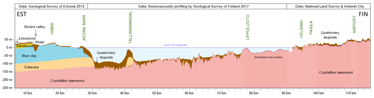
Picture: Geological profile along the proposed tunnel alignment
Source: TheLINK consortium
FinEst Link will be mainly situated in competent and stable crystalline Precambrian bedrock. Approaching the Estonian coast in the south, the crystalline bedrock dives gently under a soft layer of Ediacaran sandstone. The sandstone is a hydraulically conductive aquifer and important groundwater reservoir for Tallinn and surroundings. Overlying the sandstone there is a thick layer of blue clay which acts as an aquitard with very low water permeability. The tunnel surfaces through a 30-meter layer of limestone, shale and sandstone.
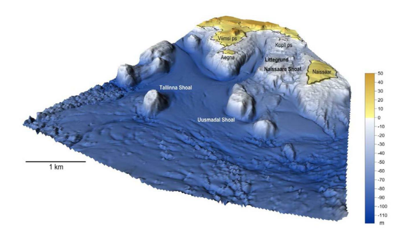
Picture: 3D surface of Quaternary sediments on the Estonian side
Source: TheLINK consortium
Additional investigations have been performed on the Estonian side, including marine geological mapping, core drilling, wells and geophysical studies. Results from these investigations have been incorporated into a 3D model showing the seabed bathymetry and thickness of the geological units.
In any case, more detailed geological and hydrogeological studies will be needed for the next phase of FinEst Link.
Vertical tunnel alignment: design requirements and boundary conditions
The vertical alignment is a crucial design element both for construction and operation. In case of a subsea tunnel, special aspects need to be considered in the design. For subsea tunnels, a sig-nificant hazard potential is caused by the possibility of high water inflow or even a complete flooding of the tunnel in case of a hydraulic short circuit up the seabed. To overcome this, a deeper tunnel alignment and correspondingly a larger rock cover has to be considered in the design. On the opposite, a deeper tunnel alignment causes higher water pressure on the final lining of the tunnel as well as higher energy consumption of the trains when they climb up the ramps to the surface. Therefore, an optimum balance between both aspects must be found in the design.
For the FinEst Link, the following requirements were defined and considered in the design of the vertical alignment of tunnel’s subsea section:
- The tunnel should be situated predominantly in a geotechnically favourable geology, that is to say the crystalline bedrock.
- The rock cover should not fall below 40 m at any point of the tunnel to avoid weathered zones and geological disturbed zones, which possibly could lead to hydraulic short circuits.
- The maximum longitudinal gradient was determined to be 10‰ to have enough traction es-pecially for heavy freight trains.
- The minimum longitudinal gradient was set at 5 ‰ to allow for a reasonable drainage of the inflowing ground water.
Since any incoming water needs to be transported from the tunnel level up to the surface, the lowest points are determined to be at the intermediate access locations where a direct connection to the surface is provided. Considering a minimum rock overburden of 40 m and a minimum longitudinal gradient of 5 ‰, an alignment with a continuous roof pitch between the two lows at the intermediate access points is not favourable since this would lead to very deep access shafts but also to a very steep and long ramp up to the tunnel portal. Therefore, an additional low in the subsea section is taken into consideration.
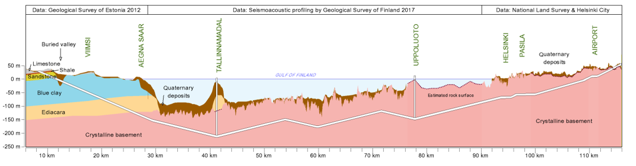
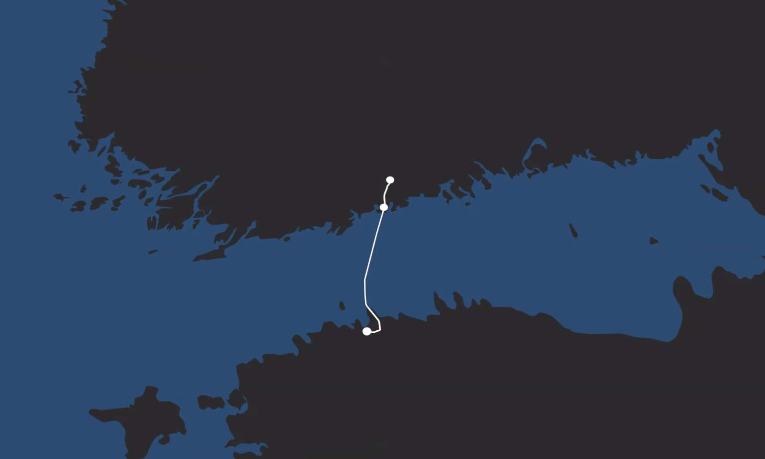
Picture: Vertical alignment of subsea tunnel section
Source: TheLINK consortium
The final vertical alignment of the tunnel section located under the Gulf of Finland is shown in the figure below. Please note that for visual reasons the vertical distance is three times the horizontal distance.
At the deepest point, the tunnel runs approximately 215 m below sea level. Due to the length of the inclined tunnel section towards Tallinn (about 20 km), the maximum longitudinal gradient of this ramp was reduced to 8.7‰ to lower the energy consumption but also the brake load of the trains. The other subsea tunnel sections have a gradient of 5‰.
On the Finnish side, FinEst Link is connected to underground stations. Therefore, the difference in altitude between onshore and offshore sections is not that high and a design gradient of 5‰ is sufficient.
The vision of a permanent land link connecting Helsinki and Tallinn has now developed into a technically and economically feasible concept for a subsea railway tunnel. We will keep you posted about the future developments of the FinEst Link project, that will eventually allow us to cross the Gulf of Finland in just 30 minutes.
Amberg Group: contributing to a smart use of space
The growing urbanization of the world is calling for a smart use of space. Combining competencies in the areas of civil engineering, surveying solutions and logistics, the Amberg Group is taking a leading role in designing tomorrow's Smart Cities and cutting-edge infrastructures, both underground and aboveground.
Follow us on our social media channels.
Related News